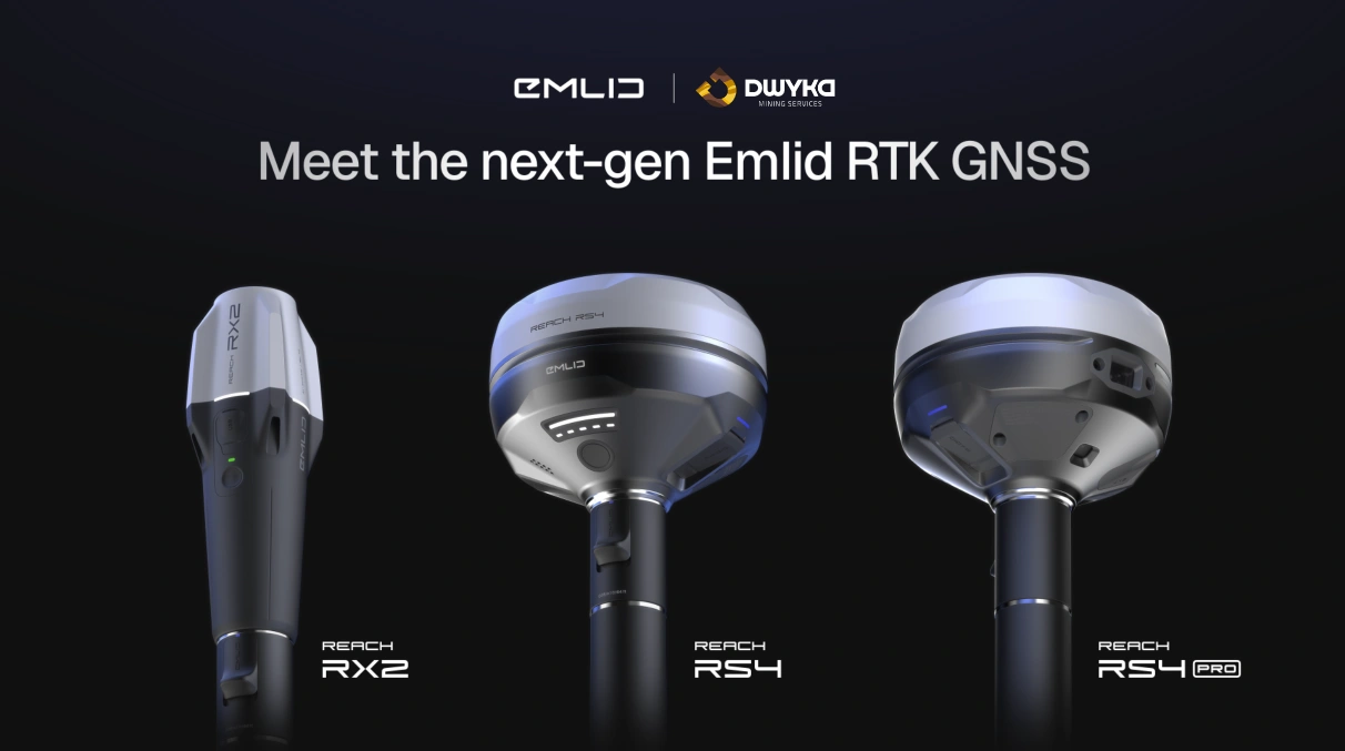
Emlid’s Reach series has become a trusted choice among surveyors, engineers, and mapping professionals who demand reliable centimetre-level accuracy in the field. With three models now available, the Reach RS2+, Reach RS3, and Reach RS4, users can choose between proven performance, advanced tilt compensation, and next-generation all-band precision.
Reach RS2+: Proven Multi-Band Reliability
The Reach RS2+ remains a benchmark for reliability and precision. It provides multi-band RTK GNSS positioning with centimetres accuracy, capable of maintaining a fixed solution over baselines up to sixty kilometres in RTK and one hundred kilometres in PPK mode.
It supports all major constellations — GPS, GLONASS, BeiDou, and Galileo, ensuring dependable coverage and fast fixes in open environments. The built-in LTE modem allows correction data to be streamed directly over the network, and with support for RINEX logging and PPP services like OPUS or AUSPOS, the RS2+ delivers consistent results anywhere on earth.
Its robust IP67-rated housing, long 22-hour battery life, and wide temperature tolerance make it a durable tool for everyday fieldwork. For standard topographic surveys, boundary marking, or mapping, the RS2+ remains an efficient and cost-effective choice.
Reach RS3: Faster Fieldwork with Tilt Compensation
The Reach RS3 builds upon the RS2+ by introducing an integrated IMU for tilt compensation. This feature allows accurate measurement even when the survey pole is tilted up to sixty degrees, eliminating the need for perfect levelling and significantly speeding up fieldwork.
Its 6-DOF IMU is calibration-free and resistant to magnetic interference, basically in plain English what this means is the device makes sure it provides you with stable results even near metal structures or electronics. The RS3 achieves a fixed RTK solution in about five seconds, maintaining accuracy in partially obstructed conditions.
With LTE, LoRa, Wi-Fi, and Bluetooth connectivity, the RS3 is easy to integrate into both single-user and multi-receiver networks. It runs for up to eighteen hours with tilt enabled and retains the same rugged, weatherproof design as the RS2+.
For construction, topographic surveys, or engineering projects where efficiency and flexibility are top of the priority list, the RS3 provides a strong balance of speed and precision.
Reach RS4: All-Band Precision for Advanced Surveying
The Reach RS4 is Emlid’s flagship receiver, designed for professional surveyors who require high performance in complex or high-interference environments. It tracks all major satellite signals, including the newer L5 and L6 bands, across 672 channels, more than triple the capability of the RS3 an impressive feat in its own right!
A new tilt compensation algorithm initialises in just a few seconds, providing rapid setup and stable readings even under canopy or in urban areas with heavy multipath interference. The magnesium alloy body delivers exceptional strength while reducing weight, and its IP68 rating ensures full dust and water protection.
The RS4’s dual-band radio system supports both LoRa and UHF transmission, allowing it to send or receive corrections depending on site requirements. With an extended operating range from –40 °C to +65 °C and support for Emlid Flow 360 cloud collaboration, the RS4 is purpose-built for large-scale field operations, drone base stations, and precision infrastructure work.
Which Model Fits Your Workflow
Here’s the thing, each model in the Reach line-up serves a fairly specific purpose:
- The RS2+: Suits professionals who need a dependable receiver for standard surveying, mapping, and long-baseline work.
- The RS3: Works best for teams that prioritise workflow efficiency and often operate in uneven or restricted areas.
- The RS4: Think of the RS4 as the top-tier option for demanding conditions, multi-receiver projects, and environments with signal interference or dense canopy coverage.
Together, they form a complete ecosystem, from foundational survey tasks to complex engineering and geodetic applications.
For South African Surveyors
All three Reach models integrate seamlessly into South African surveying workflows. Each support NTRIP corrections through local mobile networks and is compatible with TrigNet, the country’s national CORS network, allowing real-time corrections without additional infrastructure.
Their environmental resilience suits local field conditions, from the highveld’s summer heat to coastal humidity in Cape Town and dust-prone construction sites.
The receivers also support coordinate systems commonly used in South Africa, including Hartebeesthoek94 / Lo projections, ensuring data aligns with national mapping standards, which is great news for local surveyors!
This combination of accuracy, durability, and open compatibility makes the Reach range a practical alternative to far more expensive GNSS systems while maintaining professional-grade precision.
Where to Get Reach Products in South Africa
Professionals across South Africa can source the full range of Emlid Reach receivers through DWYKA Mining Services, an official supplier experienced in supporting GNSS, surveying, and digital field technologies. To learn more or request a quote, contact DWYKA Mining Services directly through our website.


